
Official websites use .gov
A .gov website belongs to an official government
organization in the United States.
Secure .gov websites use HTTPS
A lock (
) or https:// means you’ve safely connected to
the .gov website. Share sensitive information only on official,
secure websites.
GSL Releases Update to DESI Weather Analysis Tool
NOAA’s Global Systems Laboratory (GSL) has released a significant update to the Dynamic Ensemble-based Scenarios for Impact-Based Decision Support (DESI). The latest release, Version 3.3, launched in February 2025 and incorporates a host of improvements aimed at enhancing usability, visualization, and its suite of critical environmental data.
Recent releases have offered several enhancements, reflecting GSL’s ongoing commitment to user-centered design. Informed by interviews with 45 meteorologists conducted by the GSL Social and Behavioral Science team, one of the most requested enhancements was a clearer visualization of forecast timing. In response, DESI now features a simplified color table, improved labeling, and editable display options, making it easier for users to interpret complex forecast information quickly.
These updates are designed to reduce cognitive load and allow forecasters to focus on what matters most: making timely, informed decisions during high-impact events.
DESI now includes live data from the National Interagency Fire Center (NIFC), as well as National Weather Service Spot Forecasts used for fire incident management. These additions allow users to better anticipate fire behavior and assess associated weather risks.
The new release also expands DESI’s capabilities in geographic and probabilistic visualization. New basemaps and overlays from NOAA’s National Centers – including the Storm Prediction Center, Weather Prediction Center, and the Climate Prediction Center provide richer context for evaluating scenarios, and support for datasets covering Hawaii expands utility for locations outside of the continental U.S. Improvements to backend performance also mean DESI runs more efficiently in environments with limited bandwidth, making it more accessible to a wider range of users.
Other enhancements include:- Point-based graphics for localized data
- A box-and-whisker display for vertical soundings
- Integration of High-Resolution Ensemble Forecast (HREF) fields, including Freezing Rain Accumulation Model (FRAM) analysis
- Support for HREF Hawaii and National Blend of Models (NBM) Hawaii datasets
- Long-Range Ensemble Forecast (LREF) clusters for Guam
- Fixes to ensemble wind gust displays and inaccurate loading bar progress
DESI continues to demonstrate its value in the field through real-world applications. In 2023, it supported decision makers to make risk-based decisions for temporary structures during Super Bowl LVII and the Phoenix Waste Management Open based on probabilistic thresholds for wind speeds. It excelled during the August 2023 Six Rivers Lightning Complex Wildfires when used to forecast heat and lightning risks, and is often leveraged by NOAA researchers and forecasters to evaluate experimental forecast tools and systems.
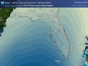
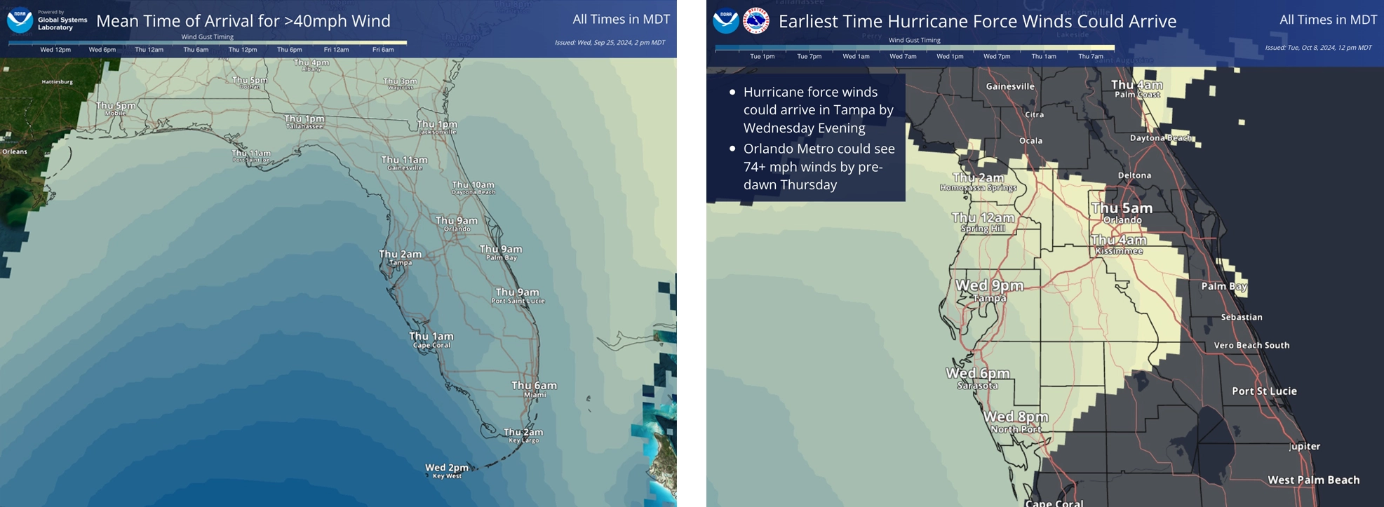 DESI timing information from Hurricane Helene is pictured left with this same timing information shown for Hurricane Milton at right. Feedback from 45 meteorologists helped make these graphics more clear, understandable, and usable for public and emergency manager consumption.
As DESI’s role continues to evolve, updates are expected to continually deepen its integration with data visualization, probabilistic forecast model output, and machine learning. These capabilities will further enhance the tool’s value in providing timely, science-based support for decision-makers facing hazardous weather events.
These DESI upgrades were achieved by a cross-disciplinary team of scientists and software engineers at GSL, the Cooperative Institute for Research in the Atmosphere (CIRA), the Cooperative Institute for Research in Environmental Studies (CIRES), and the National Weather Service, including Travis Wilson, Rob Howlett, Jebb Stewart, Phil Schumacher, Cole Vaughn, Kevin Capps, Jacob Radford, Korri Anderson, and Mike Rehnberg.
For more information on DESI and other GSL projects, visit https://gsl.noaa.gov.
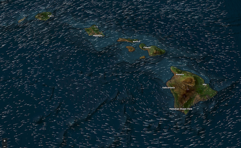
A DESI display of forecasted wind vectors for Hawaii. The addition of new datasets supported for Hawaii in DESI Version 3.3 expands the utility of the system outside the continental U.S.