
Official websites use .gov
A .gov website belongs to an official government
organization in the United States.
Secure .gov websites use HTTPS
A lock (
) or https:// means you’ve safely connected to
the .gov website. Share sensitive information only on official,
secure websites.
Research to Operations/Community (R20)
GSL's history was forged in developing tools that support the weather decision-making process. Decision support tool development began in the early 1980s with the Advanced Weather Interactive Processing System (AWIPS) and is continuing now with incremental deployments of GSL's Hazard Services. As a world leader in the development of storm-scale to global-scale weather prediction models, GSL's research is the foundation of NOAA numerical weather prediction (NWP).
Weather and Chemistry Models
 Rapid Refresh (12/2020): The Rapid Refresh (RAP) is a 13km continental-scale NOAA hourly-updated assimilation/modeling system operational at NCEP. RAP covers North America and is comprised primarily of a numerical weather prediction (NWP) model and an analysis/assimilation system to initialize that model. RAP is complemented by the higher-resolution 3km High-Resolution Rapid Refresh (HRRR) model, which is also updated hourly and covers a smaller geographic domain.
 High-Resolution Rapid Refresh (12/2020): The operational High-Resolution Rapid Refresh (HRRR) (3km grid) model system provides significant improvements to forecasts for upper-air, surface, cloud and precipitation, and thunderstorms. The HRRR model is the highest spatial and temporal (hourly-updating) resolution forecast system run by the National Centers for Environmental Prediction. It uses data from many sources, including radar and satellite data, which provide critical details to weather forecasters in rapidly changing and evolving weather events. Those forecasts in turn support emergency managers preparing and responding to severe weather impacts of all types, renewable energy generators making same-day decisions, air traffic managers conducting aviation tactical and strategic planning, wildfire managers making tactical firefighting decisions, and more.
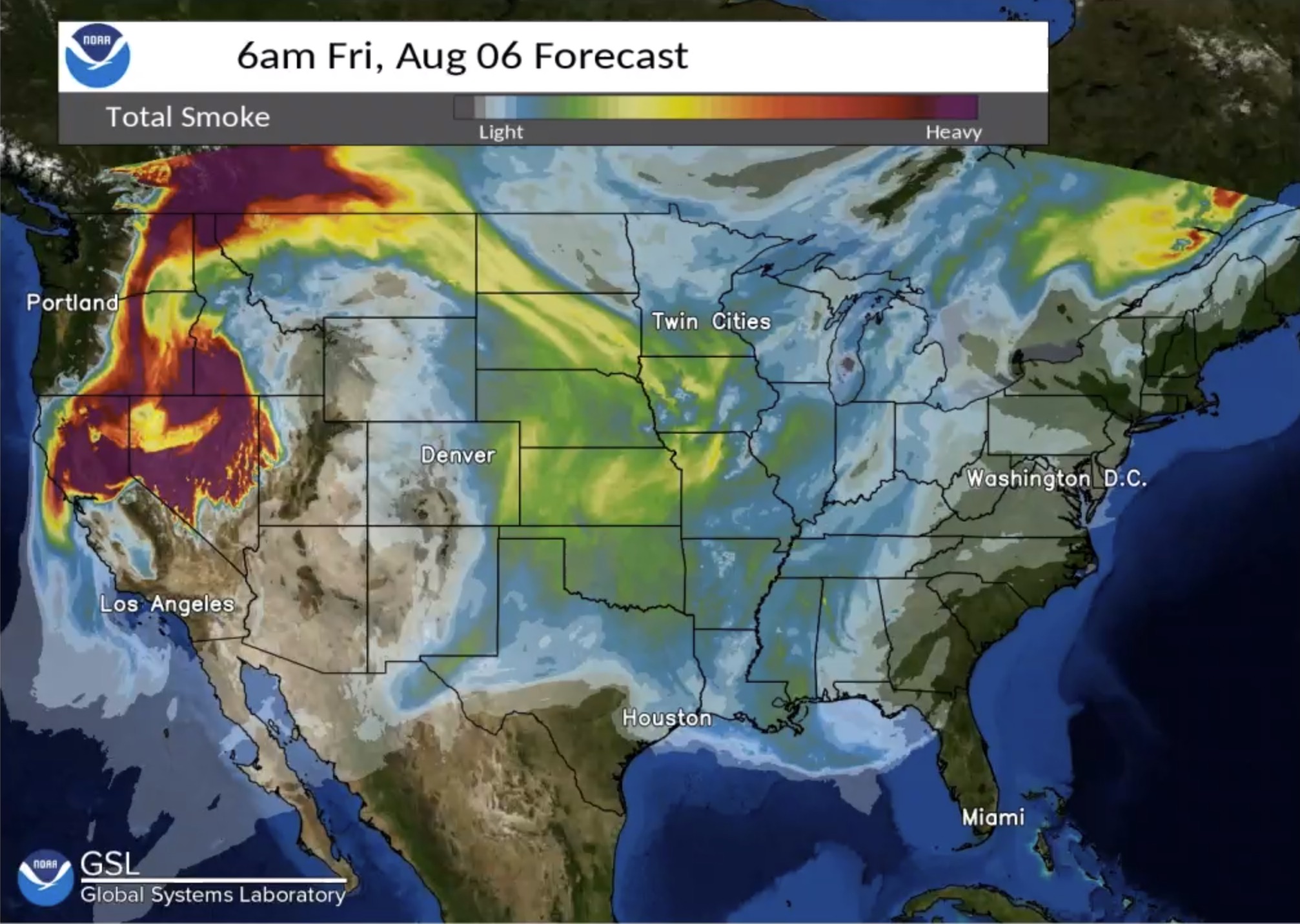 HRRR-Smoke model system (12/2020): Although the HRRR-Smoke model has been available experimentally since 2016, it just became operational as part of the HRRRv4 implementation by NWS. NOAA Incident Meteorologists (IMETs), Air Resource Advisors, and National Weather Service (NWS) forecasters use the HRRR-Smoke model to help advise the public about air quality and visibility issues caused by U.S. wildfires. From the NWS AWC: "The NWS/Aviation Weather Center (AWC) is responsible for issuing products for smoke which include height, depth, and areal extent of smoke layers, visibility restrictions, and slantwise visibility...The advent into operations of HRRR smoke is a revolutionary advance in model guidance of smoke that should greatly improve AWC’s products."
High-Resolution Rapid Refresh Data Assimilation System (12/2020): The High-Resolution Rapid Refresh Data Assimilation System (HRRRDAS) is a new data assimilation component that is the most important advancement in the HRRR model.
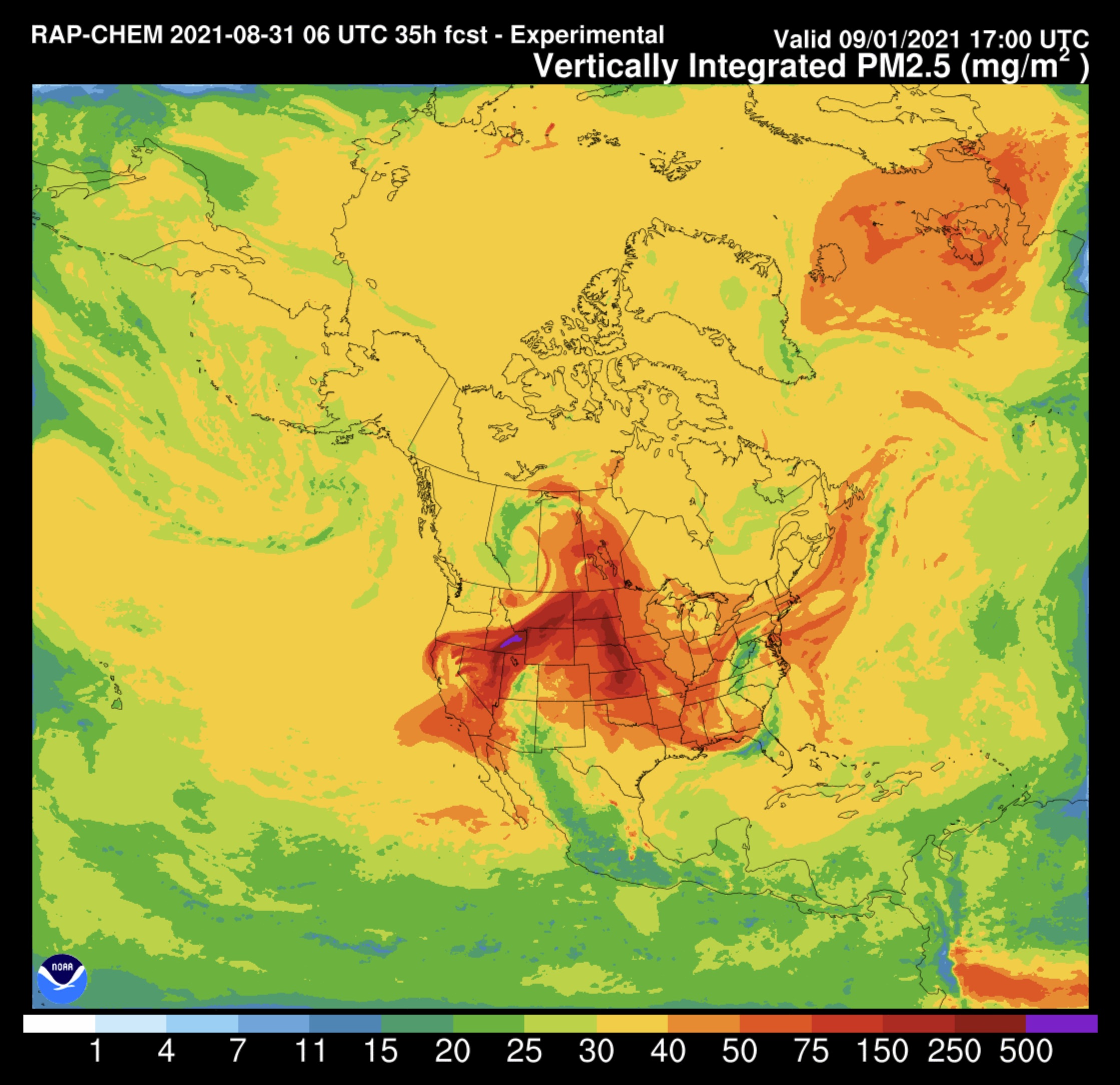
Weather and Research Forecast model (WRF-Chem) (4/2017, 11/2018, 4/2019, 1/2021): GSL scientists are the leaders and caretakers of the WRF-Chem community code. Although the WRF-Chem model is not part of the NWS operational suite of models, it is used extensively by other meteorological services around the world. WRF-Chem is an international community-developed model with the Weather Research and Forecasting (WRF) model coupled with Chemistry. The model simulates the emission, transport, mixing, and chemical transformation of trace gases and aerosols simultaneously with meteorology. The model is used to investigate regional-scale air quality, and for field program analysis, and cloud-scale interactions between clouds and chemistry. Integrating chemistry and atmospheric dynamics together at every time step makes WRF-Chem essential not only for investigating aerosol, weather, and climate interactions, but also for air quality research.
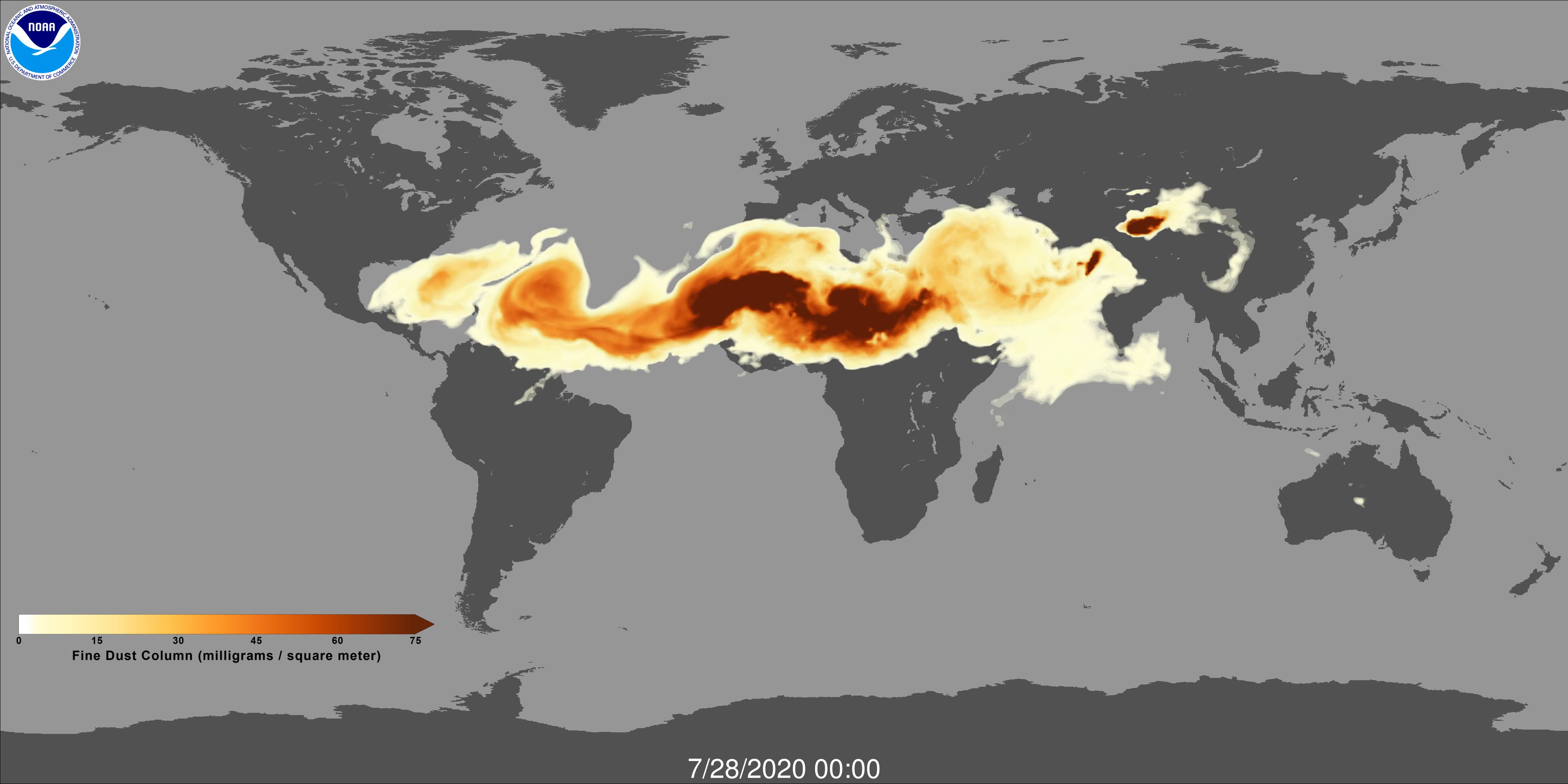 Global Ensemble Forecast System-Aerosols (GEFS-Aerosols) (9/2020): GSL, other Laboratories, and NWS led the development of the Global Ensemble Forecast System - Aerosols (GEFS-Aerosols), an atmospheric composition model that integrates weather and air quality using the Finite Volume Cubed Sphere (FV3) core. GEFS-Aerosols produces seven-day forecasts of the global distribution of some primary air pollutants: smoke, soot, organic carbon, sulfate, and large and small particles of dust and sea salt - collectively known as aerosols. Because these aerosols affect the weather, the model also provides weather forecasts. The new model is also capable of predicting the atmospheric impact of volcanic eruptions, which can disperse quantities of ash and other particulates over wide areas. The biomass burning plume rise module added in GEFS-Aerosols is from WRF-Chem, which is also used in the operational Rapid Refresh (RAP) v5 and HighResolution Rapid Refresh (HRRR) v4 models making NWS one of the first major weather forecast centers to successfully implement any type of real-time forecasted aerosol into an already world-class-operational NWP model.
Unified Forecast System Medium-Range Weather Application (2020-2021): This Unified Forecast System (UFS) Medium-Range Weather (MRW) Application targets predictions of global atmospheric behavior out to two weeks. The software is distributed and maintained through GitHub, and the release of additional applications are planned in the coming year. Collaborating researchers can use the application in real-time, and promising research code will be considered for inclusion in future versions of the operational model. Future releases of model code will enable the research community to continue to advance the model for operational use. NOAA and the modeling community also worked together to ensure the code is ready for use by students at the graduate level. The outstanding work by GSL was acknowledged by former NOAA Administrator Neil Jacobs: “The entire UFS team deserves an immense amount of credit. Making global NWP user-friendly is beyond challenging.
Unified Forecast System Short-Range Weather modeling Application (2020): NOAA and its partners are accelerating the advancement of numerical weather prediction by sharing a second application based on the Unified Forecasting System (UFS) framework with the scientific community. This code will enable users to make improvements that focus on the short-range weather applications, critical for life-saving weather and water forecasts in the U.S. during extreme events such as severe weather outbreaks, including tornadoes, as well as blizzards, floods, and hurricanes. This release is part of the ongoing effort to leverage the expertise of the weather community beyond NOAA to accelerate the emerging scientific and technological advancements of environmental prediction models.
Software
NOAA Environmental Software Infrastructure and Interoperability - ESMF/NUOPC v7.1.0 Software Package (3/2018): The Earth System Modeling Framework (ESMF) is high-performance, open-source software for building and coupling Earth system models. ESMF is a community-developed package with a large and diverse customer base that includes modeling groups from the National Weather Service, the Department of Defense, NASA, National Center for Atmospheric Research (NCAR), and other federal and international modeling centers. The National Unified Operational Prediction Capability (NUOPC) Layer defines conventions and templates for using ESMF, and makes it simpler to adopt the framework.
Testing and Evaluations
Numerical Weather Prediction evaluations: The multi-agency Developmental Testbed Center (DTC), a collaboration between NOAA GSL, the National Science Foundation's National Center for Atmospheric Research (NCAR), and the United States Air Force conducts major tests and evaluations of improvements to NWP forecast system components provided by the NWP research and operational communities. These tests and evaluations are critical for selecting proposed changes that need to be transitioned to operational centers. For example, they are critical for the selection of the optimal physics packages, data assimilation strategies, and ensemble configurations used in the Hurricane Weather Research and Forecast (HWRF) model, the UFS Medium-Range Weather Application (including the operational Global Forecast System - GFS), and now in the UFS Short-Range Weather Application (including the Rapid Refresh Forecast System, RRFS, being developed by GSL and collaborators). GSL scientists are key participants in these tests and evaluations, providing subject matter expertise as well as management oversight.
NWS Hurricane-Weather and Research Forecast improvements (2016-present): The Hurricane Weather Research and Forecast system (HWRF) is NOAA's flagship regional model for tropical cyclone prediction. The DTC serves as a neutral evaluator of new innovations from the research community that have the potential to improve HWRF forecasts. The DTC assists developers in adding their innovations to the HWRF code base, and then tests and evaluates these innovations with input from the developers and the National Weather Service (NWS). The evaluation results are then shared with the developers and the NWS. If the NWS determines that an innovation provides sufficient forecast improvements, they will include the innovation in the next operational HWRF implementation. The research innovation can then contribute to improved forecasts of tropical cyclone track, intensity, structure, and precipitation, reducing loss of life and helping to protect property when tropical cyclones threaten.
Community Code Support
Gridpoint Statistical Interpolation (GSI): The DTC maintains and supports a community version of the Ensemble Kalman Filter (EnKF) system as well as the community version of the Gridpoint Statistical Interpolation (GSI). The testing and support of this EnKF system at the DTC includes both regional numerical weather prediction (NWP) applications coupled with the Weather Research and Forecasting (WRF) Model, as well as global NWP applications. With increased data assimilation research conducted using the operational GSI/EnKF, then there are more community researchers gaining extensive knowledge on the operational data assimilation system to provide innovative improvements. Those research results and knowledge can directly contribute to improve the operational data assimilation system and further improve the NWS weather forecasts to save lives and protect property.
Unified Post Processor (UPP) improvements (2015-present): The DTC maintains a community version of the UPP code that aligns with what is used operationally at NCEP. Features and developments from NCEP are continually brought back into the community UPP package and likewise, community members are encouraged to provide new features to DTC for proposal into operational code. The ability of the general research community to test innovations within a model framework identical to those run in the NCEP model suite is critical for effective R2O and implementation of innovations into operations. In addition, independent evaluation of testbed results through rigorous verification techniques allows the DTC to evaluate promising new model developments and physics parameterization modifications. Forecast improvements from these model innovations and modifications are vital to the continued safety of both lives and property. The build procedure and software dependencies have been updated to fit within the UFS software framework, to further align the community software with operational software, to help facilitate code management procedures.
Common Community Physics Package (CCPP) improvements (2018-present): As part of the Unified Forecast System (UFS), the Common Community Physics Package (CCPP) is designed to facilitate the implementation of physics innovations in state-of-the-art atmospheric models, the use of various models to develop physics, and the acceleration of transition of physics innovations into operational NOAA models. The CCPP-physics contains the parameterizations and suites that are used operationally in the UFS Atmosphere, as well as parameterizations that are under development for possible transition to operations in the future. The CCPP-Framework is scheduled for future NWS operations as a component of the GFSv17 model.
Model Evaluation Tools (METplus) (2019, 2020): METplus is a verification framework that spans a wide range of temporal (short-term to long-term) and spatial (storm to global) scales. It is intended to be extensible through additional capability developed by the community. The core components of the framework include MET, the associated database and display systems called METviewer and METexpress, and a suite of Python wrappers to provide low-level automation and examples, also called use-cases.
Assessments
FAA Aviation Weather Research Program (AWRP) Product Quality Assessments (1993-present): GSL provides independent scientific assessments of weather research products developed by other sources (e.g. MIT/Lincoln Labs, NCAR, etc.) through the Federal Aviation Administration's Aviation Weather Research Program. The assessments ensure that the products and tools are scientifically accurate and provide value to the individual decision-maker within their operational aviation decision processes. Ultimately this research and resulting product assessments increase the safety of aviation and the national air space.
Advanced Weather Interactive Processing System (AWIPS)
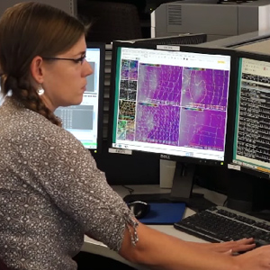 AWIPS II Ensemble Tool (2018): The AWIPS-II Ensemble Tool was developed to help forecasters assess and communicate uncertainty in their forecasts and improve decision support services for their customers. The tool provides quantitative information about the probabilities an event will occur. This tool enables forecasters to provide clients with individualized decision support for assessing hazard contingencies in terms of the most likely scenario, most dangerous scenario, and possible extent or scale of the impacts (cities, transportation, critical national infrastructure). It also evaluates a wide range of emerging national, local, and regional threats using a nearly continuously updated ensemble of predictive numerical weather guidance (200+ predictions per day).
AWIPS Hazard Services Watch/Warnings/Advisories Applications: Hazard Services v1.0 Hydrology-Initial Operating Capability (Hydro-IOC) (2019): Hazard Services is a major enhancement that will ultimately replace all watch, warning, and advisory generation software in AWIPS. The purpose is to consolidate, re-design, and re-implement the AWIPS hazard services tools using the best science and engineering available while optimizing them for performance. Hazard Services v1.0 (Hydrology-Initial Operating Capability) software code for watches, warnings, and advisories for flooding and flash flooding was handed off to NWS for limited operations prior to later nationwide deployment in AWIPS Operational Build 19.3.1.
AWIPS Hazard Services v2.0 Winter Weather, Hydrology Hazard Simplification, Common Alerting Protocol (CAP) (2021-2022): Hazard Services v2 incorporation into NWS AWIPS OB 20.2.1 which includes Winter Weather and Hydrology Hazard Simplification plus the Common Alerting Protocol (CAP) formatter.
AWIPS Hazard Services v3.0 Non-Precipitation Weather (NPW) Hazards, NPW Hazard Simplification, and Common Alerting Protocol (CAP) messages for NPW hazards (2021-2022): Hazard Services Version 3 contains enhancements to the long-duration hazard product creation workflow and the ability to issue operational Non-Precipitation Weather hazard products. These components were spread across two AWIPS check-in periods (OB21.3.1 and OB21.4.1). Around 15 NWS offices had early access to these improvements through an AWIPS Test Authorization Note (ATAN) #1242, which allowed for the first operational issuance of Winter Weather and Non-Precipitation Weather hazards through Hazard Services in the Winter/Spring 2021 season. GSL collected feedback on their progress and incorporated their suggested enhancements into the Version 3 release.
Data Delivery
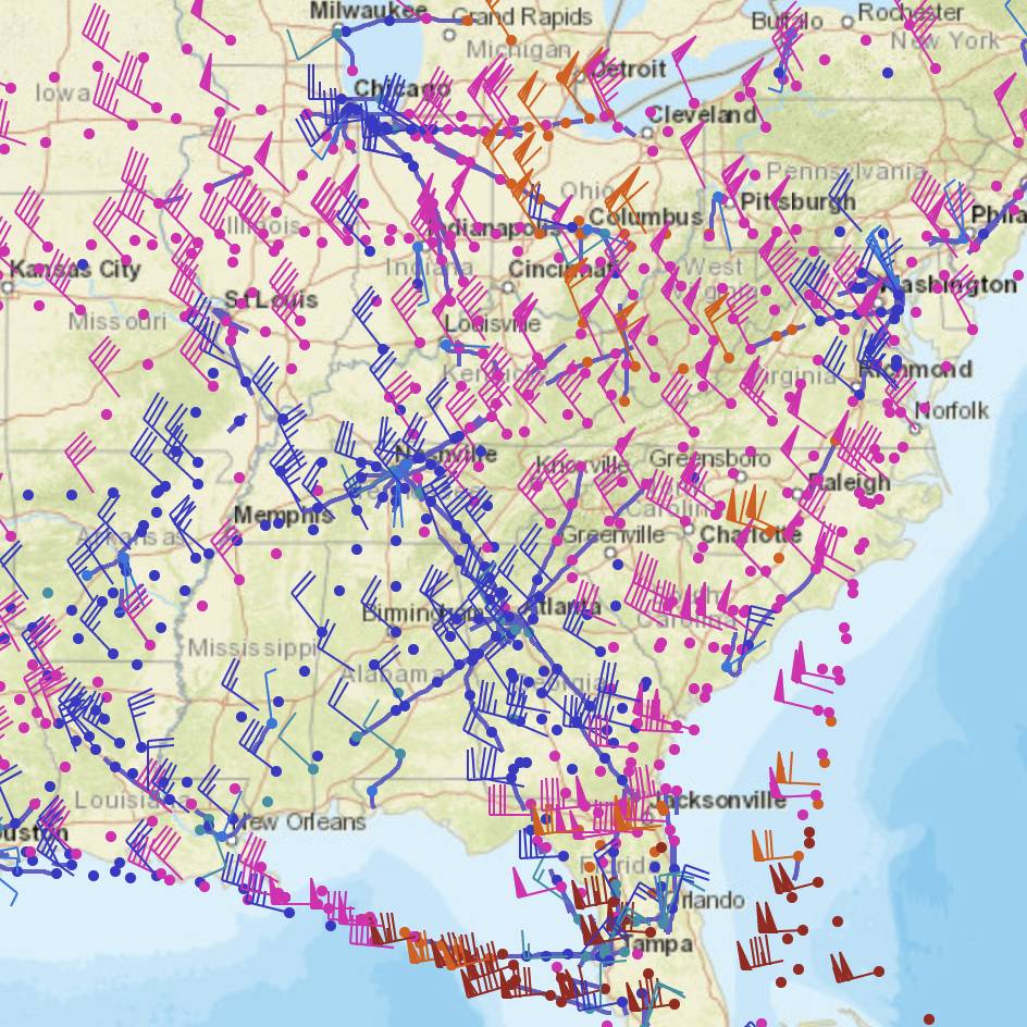 Meteorological Assimilation Data Ingest System (2001-present): The Meteorological Assimilation Data Ingest System (MADIS) was developed by GSL. It is now operational, but research continues to enhance the system to fully leverage advances in technology and science. MADIS provides access to high temporal frequency atmospheric observations. Since 2001 MADIS has been a crucial data delivery system to NWS Weather Forecast Offices and numerical weather prediction models. The GSL MADIS team partnered with non-NOAA entities to collect environmental observations from their networks, integrate their observations with NOAA's, quality control the observations, and provide a standardized interface for delivering this information to NOAA operations and the greater meteorological community. MADIS' centralized data acquisition and delivery system reduces the cost of operations for NWS Weather Forecast Offices, which would otherwise be required to individually, and often redundantly, collect observations locally. By assimilating private sector as well as government purchased observations, MADIS saves NOAA the costs of new observing systems and the cost of maintenance for these systems. MADIS attained operational status at NWS in January 2015. The MADIS observations are used to improve NWS numerical weather prediction models by helping to better initialize weather models at NWS for a better forecast, particularly for severe and hazardous weather. NWS forecasters use MADIS data to help with their forecasting efforts for severe weather events. MADIS data is also used for the verification of NWP models. Through software packages, GSL MADIS continues to enlarge and enhance operational NWS MADIS.