
 )
)
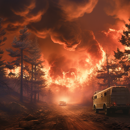
Fire Weather Research
Where Science Meets the Blaze.

Understanding New Frontiers
NOAA's Global Systems Laboratory (GSL) plays a vital role in research to support a fire-ready nation. GSL research includes real-time fire and smoke detection using new imaging capabilities from geostationary and polar-orbiting satellites. GSL also advances forecasting and monitoring to maximize lead times for fire weather warnings and real-time changes in fire weather and behavior. Advancements in air quality and wildfire smoke predictions help inform vulnerable communities of poor air conditions with as much time to prepare as possible.
Firefighters, land management agencies, emergency managers, local officials and frontline communities will benefit from GSL research and tools to better prepare for and manage fires and wildfire smoke across the nation.
Fire Weather
- Temperature: Higher temperatures can dry out vegetation, making it more flammable.
- Humidity: Low humidity levels contribute to the drying of fuels and increase the likelihood of ignition and rapid fire spread.
- Wind: Strong winds can spread fires quickly by pushing flames into new fuels, carrying embers to start new fires, and increasing oxygen supply to the fire.
- Precipitation: Lack of rain and/or snowfall can lead to dry conditions conducive to wildfires, while rain can help to suppress them but can also initiate flash flooding and debris flows.
- Fuel Moisture: The moisture content of live and dead vegetation affects how easily it can ignite and sustain a fire as well as controlling how much energy is released.


GSL hosts the NOAA Fire Weather Testbed (FWT) a facility for users, researchers and social scientists to test and evaluate new tools to better prepare for and manage fires and wildfire smoke across the nation. The NOAA FWT provides research to operations and operations-to-research support with advanced weather and smoke models, decision support tools and user evaluations to accelerate the delivery of critical products for managing wildfires. The NOAA FWT is a collaborative effort between NOAA's GSL, National Weather Service (NWS), and National Environmental Satellite, Data, and Information Service (NESDIS), but reaches beyond NOAA to build partnerships facilitating collaborations across the numerous municipalities engaged in wildland fires.

Advanced Technology
An artificial intelligence method of modeling current and future wildfire behavior is identifying and measuring the fire radiative power (FRP) and how intensely the fire is burning. One GSL project used AI to predict hourly FRP from past FRP data collected from polar or geostationary satellites. These models did as well and outperformed the current method of modeling hourly FRP.
GSL has a deep learning framework for smoke detection that can be used as a pollution exposure assessment tool. Public health officials require reliable analysis of the location, density, composition and duration of smoke.
GSL is leading the effort to develop an observation network that will provide unique high-resolution profiles of wind, temperature and humidity near the Earth's surface, along with smoke, aerosol and radiation observations. This new network will provide state-of-the-art observations to evaluate how wildfires and smoke impact this layer and vice versa.
GSL research includes real-time fire and smoke detection using new imaging capabilities from geostationary and polar-orbiting satellites to maximize lead times for fire weather warnings.
Advancements in air quality and wildfire smoke predictions help inform vulnerable communities of poor air conditions with as much time to prepare as possible. GSL scientists lead development of the NWS's next-generation model, the Rapid Refresh Forecast System - Smoke (RRFS-Smoke). RRFS-Smoke simulates the emissions and transport of smoke from wildland fires and predicts the impact of smoke on the weather and visibility on a 3 km grid over North America. RRFS-Smoke estimates "near-surface smoke," which impacts air quality and visibility, and "vertically integrated smoke," which predicts smoke concentrations from the surface to about 25 km in the atmosphere.
Fires devastate the landscape, causing "burn scars." When these burn scars experience heavy rain, boulders, trees, and dirt can create deadly debris flows. GSL-developed models predict heavy rainfall events to help the NWS warn the public in advance.
GSL researchers look at the information needs and critical decision points of our partners leading up to and during weather events. They study how to develop risk communication messaging with actionable information, decision timelines, and lead evaluations by users to improve their experience. Their research helps inform the development of more
Our research investigates:


A Closer Look
Dive into the heart of the blaze with NOAA's Fire Weather Research projects. Discover groundbreaking studies and innovations that are shaping the future of fire forecasting. Join us on this illuminating journey!

Fire weather modeling: RAP Smoke
GSL's Rapid Refresh - Smoke (RAP-Smoke) model simulates the emissions and transport of smoke from wildfires and predicts the impact of smoke on the weather on a 13km grid.
RAP Smoke estimates "near-surface smoke" which impacts air quality and visibility) and "vertically integrated smoke" which predicts smoke concentrations from the surface to about 25km in the atmosphere. The RAP-Smoke domain covers the entire North and Central Americas.
Fire weather modeling: Experimental Hourly Wildfire Potential (HWP)
GSL-developed models can predict real-time changes in fire weather and behavior. GSL's Hourly Wildfire Potential (HWP) is an index derived from the GSL-developed High-Resolution Rapid Refresh (HRRR) model predictions of temperature, winds, humidity and soil moisture conditions. The HWP index predicts the expected changes in fire behavior due to windstorms or precipitation. It also predicts when the wildfire could "lay down."


Air Quality Monitoring: GEFS Aerosols
GEFS-Aerosols is an atmospheric composition model that integrates weather and air quality forecasts to produce week-long forecasts of aerosol components including wildfire smoke, soot, organic carbon, particulate sulfate, dust, sea salt, and volcanic ash.
This model was implemented into NOAA operations on September 23, 2020 as one of the ensemble members of the Global Ensemble Forecast System.
HRRR Smoke Tour and the 2020 Fire Weather Season
This tour, created by GSL walks viewers through the 2020 fire season and how HRRR Smoke can be used to show how the smoke from wildfires moves across the U.S.
Partners
The NOAA Fire Weather Testbed is a collaborative effort between NOAA's GSL, National Weather Service (NWS), and National Environmental Satellite, Data, and Information Service (NESDIS).
Future Work
Future GSL research will involve predicting fire behavior and developing decision-support criteria, with objectives to:

Our Mission
Lead research and directed development through the transition of environmental data, models, products, tools, and services to support commerce, protect life and property, and promote a scientifically literate public.
Research Areas
Organizational Excellence, Earth System Prediction, Advanced Technologies, and Decision Support are the foundation to achieving the GSL Grand Challenge: Deliver actionable global storm-scale prediction and environmental information through advanced technologies to serve society.