Products
From weather observation data to meaningful output, GSL engages users to understand their decision support and risk communication needs so they can respond to weather effectively. The foundations of GSL are in creating weather information systems oriented towards user requirements and fostering the flow of information between operations and research.
Our products are used by: National Weather Service, Storm Prediction Center, National Hurricane Center, U.S. Department of Energy, and Federal Aviation Administration.


Experimental Products
These models are pre-operational and should not be used for operational purposes. The model websites are not supported 24/7 and may be unavailable during system outages.
Hazard Services (HS)
GSL leads the development of Hazard Services, a powerful software package that modernizes how the NOAA NWS generates hazardous weather products. HS is a multi-year, multi-phase effort to streamline the process to create a forecast or weather warning with a unified workflow. This modernized methodology provides a more robust and precise depiction of hazard timing and spatial extent. The software also contains an extensible dissemination and formatting architecture, allowing for generation of modernized alerting formats, such as Common Alerting Protocol (CAP).
Hazard Services is being transitioned to operations as portions of the system are developed, tested, and approved.

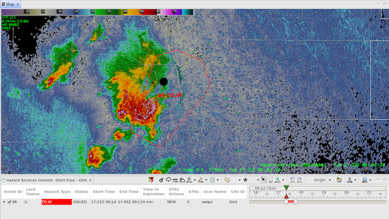
Hazard Services display as captured by the NWS Omaha Forecast Office showing how they use Hazard Services to issue a tornado warning (outlined by a red line).
AWIPS Tsunami Operations Messaging Service (ATOMS)

Caption: The AWIPS Tsunami Operations Messaging Service under development by GSL.
GSL is developing a modernization of the NOAA National Tsunami Warning Service called AWIPS Tsunami Operations Messaging Service (ATOMS). ATOMS provides consistent integrated decision support systems, product generation and formatting, and dissemination capabilities for the NOAA Tsunami Warning Centers. The hardware for ATOMS was installed in January, 2024.
The Integrated Decision Support Services (IDSS) Engine
The Impact-based Decision Support System (IDSS) Engine developed by GSL is a sophisticated tool that provides tailored weather information to support critical decision-making processes. The IDSS Engine is a web-based decision support tool that integrates real-time data, advanced modeling, and user-specific criteria. This tool helps meteorologists in the NWS provide clear, timely, and precise guidance to key stakeholders by providing actionable insights to emergency managers, government partners, and electronic media. The IDSS Engine enhances the ability to respond effectively to weather-related threats, improving public safety and operational efficiency during high-impact events.
Dynamic Ensemble-based Scenarios for Impact-based Decision Support (DESI)
DESI is a powerful decision support web and cloud-based application that provides forecasters, decision-makers, and other stakeholders with ensemble-based weather forecast information and visualizations. NWS meteorologists can use a prototype DESI to make graphics for their partners and the public that communicate when and where impacts are expected to occur, and the confidence in those estimates.

A DESI display showing the mean time of arrival of winds greater than 40mph from Hurricane Helene impacting the Florida coast.
WAVE
The Weather Archive and Visualization Environment (WAVE), developed by GSL, is a web-based interface designed to help users produce detailed weather graphics for public and professional use. WAVE supports informed decision-making and enhances public awareness of weather conditions.
Threats-in-Motion (TIM)
GSL is researching Threats-in-Motion (TIM). TIM is a warning generation approach that enables the NWS, and international meteorological agencies, to advance severe thunderstorm and tornado warnings from the current static polygon system to continuously updating polygons that move forward with a storm. With TIM, a warning polygon is attached to the threat and moves forward along with it. This provides more uniform, or equitable, lead time for all locations downstream of a storm.
A video showing supercells over eastern Minnesota and western Wisconsin with overlays of the experimental Threats-in-Motion concept where the warning moves and evolves with the storm. Severe thunderstorm warnings are outlined in a yellow line with their potential path in shades of yellow. The tornado warning is outlined in red with shades or red showing the potential path.
Testbeds
GSL hosts the NOAA Fire Weather Testbed and participates in the NOAA Hazardous Weather Testbed with several experimental products under evaluation each year. The primary goals of the testbeds are to accelerate the transfer of promising new tools from research to operations, and inspire new initiatives for operationally relevant research, which focuses on improving fire weather prediction and response.
Product Evaluation
GSL provides operational agencies with technology and tools for improving the accuracy and quality of weather information at critical decision points, thus improving services to the public. An interdisciplinary team of meteorologists, physicists, mathematicians, and engineers provide meaningful quality assessment measures, network-enabled verification services for automated decision support and verification system unification, and independent comprehensive analyses to interpret and communicate the accuracy of weather forecasts for improving services to the public.
The Model Analysis Tool Suite (MATS) is a software application developed in-house by GSL to assess the forecast skill of regional and global weather models. MATS consists of individual modules, which are each designed to verify a particular meteorological facet (e.g. ceiling heights, radar reflectivities, precipitation accumulations, etc.). Using MATS, model developers can produce interactive, publication-quality plots to quickly and easily compare the skill of individual models' forecasts as they occur, as well as assess the performance of models under development. For more information, visit the
Model Evaluation Tools (MET)
MET is a suite of state-of-the-art verification tools used by researchers to assess how well models are performing.
The Model Analysis Tool Suite (MATS)
MATS is a software product developed in-house by GSL to assess the forecast skill of regional and global weather models. MATS consists of individual applications, which are each designed to verify a particular meteorological facet (e.g. ceiling heights, radar reflectivities, precipitation accumulations, etc.). Using MATS, model developers can produce interactive, publication-quality plots to quickly and easily compare the skill of individual models' forecasts as they occur, as well as assess the performance of models under development.
Quality Assessments for Aviation Weather
GSL's quality assessment product development team conducts independent comprehensive assessments to interpret and communicate the accuracy of aviation weather guidance. For example, the Forecast Icing Product is being evaluated to determine the changes associated with using higher resolution numerical weather prediction output to generate the icing information.
Our Mission
Lead research and directed development through the transition of environmental data, models, products, tools, and services to support commerce, protect life and property, and promote a scientifically literate public.
Research Areas
Organizational Excellence, Earth System Prediction, Advanced Technologies, and Decision Support are the foundation to achieving the GSL Grand Challenge: Deliver actionable global storm-scale prediction and environmental information through advanced technologies to serve society.
Global Systems Laboratory

