
Official websites use .gov
A .gov website belongs to an official government
organization in the United States.
Secure .gov websites use HTTPS
A lock (
) or https:// means you’ve safely connected to
the .gov website. Share sensitive information only on official,
secure websites.
Improved Lake-Effect Snow Forecasts Through Experimental Coupling of Weather Prediction With Lake Hydrodynamics
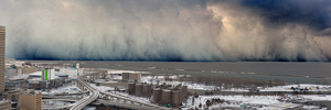
Since mid-2017, a NOAA Oceanic and Atmospheric Research (OAR) / National Weather Service (NWS) cross-line office team has been working together to improve lake-effect snow, lake ice, and visibility forecasts. Lake-effect snowfall is one of the most hazardous weather events in the Great Lakes region, and forecasting the timing and amount of snow is extremely challenging.
For the 2018/2019 winter season in the Great Lakes region, the researchers initiated a Hydrometeorology Testbed (HMT). OAR’s Earth System Research Laboratory (ESRL) Global Systems Division (GSD), Great Lakes Environmental Research Laboratory (GLERL), and the Cooperative Institute for Great Lakes Research (CIGLR) have been working together with NWS forecasters from Detroit toward coupling operational weather prediction with lake hydrodynamics.
GSD and GLERL reached a key milestone in late February 2019 as they began to run experimental “coupled” versions of the Great Lakes Operational Forecast System (GLOFS) and the High-Resolution Rapid Refresh (HRRR) model. They began to use, in real time, experimental lake-model temperature and ice coverage data from GLERL for the Great Lakes in the experimental 3km High-Resolution Rapid Refresh (HRRR) weather prediction model. They showed the use of the Finite Volume Community Ocean Model (FVCOM) model data improves HRRR forecasts of lake-effect snow and general forecasts in all seasons over the Great Lakes region. In turn, HRRR forecasts are used to drive the FVCOM model over the Great Lakes, so HRRR weather forecast improvements lead to yet more accurate FVCOM predictions of lake conditions. In retrospective tests of the November 2014 Buffalo, NY lake-effect snow event, use of the FVCOM lake temperature and ice data improved the HRRR snow forecast by up to 0.5 meters in western NY (Fig. 1 below).
The testbed results will inform NOAA R20 Transition Plans.
- GLOFS will transition from GLERL to NOS
- HRRRv4 will transition from ESRL to NCEP
The HRRR-FVCOM coupling is part of the next HRRR/RAP model upgrade planned for NCEP in 2020. This linkage is a step towards increasing OAR coupling of earth-system components to improve operational NOAA prediction capabilities.
Philip Chu and Eric Anderson at GLERL, Ayumi Manome and Lindsay Fitzpatrick (CIGLR) in Ann Arbor, MI and Curtis Alexander and Stan Benjamin (GSD) started this project in 2017 using support from a NOAA Office of Weather and Air Quality (OWAQ) project under the Hydrometeorology Testbed (HMT) and the U.S. Weather Research Program (USWRP). Greg Mann, Science Operations Officer (SOO) from NWS Detroit, has been a key colleague in carrying out initial retrospective HRRR experiments with detailed FVCOM lake surface temperature and ice concentration. Eric James (CIRES), Tanya Smirnova (CIRES), and Bob Lipschutz (CIRA) have led the GSD effort to acquire and test this more accurate Great Lakes data. James Nelson (NWS/NCEP/WPC) facilitated the Testbed Demonstration effort with Sara Sienkiewicz (ISMG), Bill Lamberson (ISMG) and Michael Bodner (WPC), during the Winter Weather Experiment.
For more information contact: Susan Cobb 303-497-5093