
Official websites use .gov
A .gov website belongs to an official government
organization in the United States.
Secure .gov websites use HTTPS
A lock (
) or https:// means you’ve safely connected to
the .gov website. Share sensitive information only on official,
secure websites.
GSL offers new educational tour "HRRR Smoke and 2020 fire season"
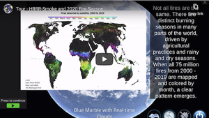
Four million acres burned in California alone this year, making 2020 a record fire season for the Western U.S. To explore this historic wildfire season, The Global Systems Laboratory’s (GSL) Science On a Sphere® (SOS) team released a new interactive educational tour about the 2020 wildfires on its free mobile app - SOS Explorer™ (SOSx). “Tour - HRRR Smoke and the 2020 fire season” explores how NOAA satellites detect fires and how atmospheric research models like the High-Resolution Rapid Refresh - Smoke model can predict how smoke from wildfires will move in the atmosphere. The tour includes post-tour exercises for students.
Science On a Sphere Explorer™ datasets can be quite complex. Tours guide users through a story using science datasets in a way that makes them understandable and more tangible. Tours incorporate supplemental media - images, videos, audio, webpages - as well as text and questions to support user learning.
You can find more tours here: https://sos.noaa.gov/education/sosx-tours/
Do you have an idea for a tour? Reach out to hilary.peddicord@noaa.gov