
Official websites use .gov
A .gov website belongs to an official government
organization in the United States.
Secure .gov websites use HTTPS
A lock (
) or https:// means you’ve safely connected to
the .gov website. Share sensitive information only on official,
secure websites.
GSL experimental model simulates Hunga Tonga–Hunga Ha‘apai eruption
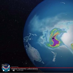
On January 15, 2022 a powerful underwater volcanic eruption blanketed the island nation of Tonga with ash, but not before it also rocketed ash, dust, and other particles high into the atmosphere. Volcanic eruptions inject sulfur gases and ash into the troposphere and sometimes the stratosphere, and are one of the most important drivers of climate variability. The sulfate aerosols can live in the stratosphere for 1-2 years, scattering sunlight at the top of the atmosphere and cooling the surface.
After the Tonga volcano eruption, NOAA Global Systems Laboratory and CIRES scientists ran their experimental GEFS Aerosols model to simulate how and where aerosols emitted from the eruption would be carried by the wind over the next 12 days. Because there wasn’t much data to begin with, GSL and CIRES scientists had to make some assumptions. First, they assumed the eruption lasted 5 hours and had an umbrella-shaped injection of ash and SO2. They also estimated a top height of 18km. This visualization opens with satellite images of the eruption, but then switches to the amount of toxic chemicals released into the atmosphere:
This was the first time GSL has conducted an experiment like this, and the new knowledge gained prepares us for future eruptions. With good satellite or radar data about eruption injection heights, we can produce quality forecasts including the impacts of emissions on numerical weather prediction. Thanks to CIRES scientists Li “Kate” Zhang and Haiqin Li for conducting the experiment and to Eric Hackathorn for the visualization.