GSL transitions a significant upgrade to NWS's MADIS

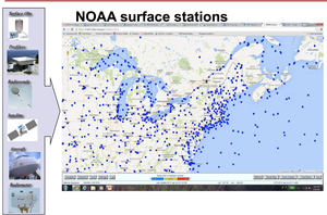
GSD met a major multi-year milestone on September 4, 2019, when a significant upgrade to the Meteorological Assimilation Data Ingest System (MADIS) went live in NOAA National Weather Service (NWS) operations. MADIS ingests weather data from both NOAA and non-NOAA providers, implemented quality control checks, and provides an interface for the public to access a wide array of observations from hundreds of sources in a uniform format. MADIS ingests observations from over 2.3 million locations a day, providing more than 68 million quality-controlled observations to users daily, which is just over 2.8 million observations per hour.NOAA Surface Observing Systems Locations
MADIS was designed to extend NOAA's observational assets by leveraging partnerships with non-NOAA entities such as international agencies, federal, state, and local agencies, universities, volunteer networks, and the private sector.
MADIS collects and provides several types of data including:
- Meteorological Surface.
- Hydrological Surface.
- Profiler data (Wind, RASS, Sodar, Radiometer).
- Global Position System Meteorological (GPS-Met).
- Aircraft Based Observations and vertical profiles.
- Snow
- Satellite (Winds and Radiance)
- Surface analyses grids derived from MADIS surface meteorological sites.
NOAA and non-NOAA Surface Observing Systems Locations
MADIS version 2.2 includes provider additions to the following data types:
- Automated Flood and Warning System (AFWS), 728 new sites from 8 new providers.
- National Mesonet (NM), 790 new sites from 10 providers.
- Department of Transportation, 628 new sites from 12 providers.
Enhancements to the Aircraft Based Observations (ABO) component of MADIS include decreased latency in observation to end-user, as well as the transition of the AMDAR website hosted by GSD to NWS operations. As a result, MADIS has become the Global Data Center (GDC) for the World Meteorological Organization to acquire ABO data.
MADIS continues to be a critical data delivery system for the NWS. NWS forecasters and many other users use MADIS data each day to provide information to help protect life and property. Access to these data is crucial in enhancing forecaster situational awareness. MADIS observations also help to improve numerical weather prediction by improving the quality, quantity, and temporal frequency of observations available to NWS global and regional data assimilation and modeling systems. MADIS's centralized data acquisition reduces cost by eliminating the need for NWS Weather Forecast Offices to collect local observations.
By collecting private sector as well as government-purchased observations, MADIS saves NOAA the costs of establishing new observing systems and associated maintenance costs. MADIS data is used by other government agencies such as the FAA and Department of Defense (DOD), other research organizations, the private sector, and the general public.
GSD continues to run MADIS quasi-operationally in a research environment to leverage advancements in science and technology to improve data ingest, quality control, and distribution methods, and integrate additional datasets and providers.

For more information contact: Susan Cobb 303-497-509
