
Official websites use .gov
A .gov website belongs to an official government
organization in the United States.
Secure .gov websites use HTTPS
A lock (
) or https:// means you’ve safely connected to
the .gov website. Share sensitive information only on official,
secure websites.
Advanced Technology Division
Explore and apply new technologies and methodologies in computing, modeling, visualization, data access and delivery to advance NOAA’s earth system prediction and decision support capabilities
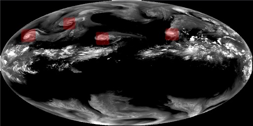
Depiction of a machine learning algorithm used to identify hurricanes and typhoons (red boxes) in GOES satellite data →
Focus Areas:
- Innovative numerical methods and software design that improve the performance, portability, and scientific accuracy of models running on next-generation exascale computers
- Improve cloud computing capabilities to address computing and data challenges of the end-to-end Unified Forecast System used by NOAA, EPIC, and the research community
- Develop machine learning algorithms to increase the utilization of observations in data assimilation, improve model prediction capabilities, and enable a better understanding of diverse, dense and complex data
- Investigate new techniques to analyze, integrate, display, and interpret data to serve diverse applications and end-user requirements
- Explore advanced data assimilation methodologies and other techniques that improve the scientific accuracy and computational efficiency of assimilation models
Technologies being Explored
- Cloud computing
- Machine learning
- High-Performance Computing with CPU, GPU, and ARM processors
- Advanced modeling and data assimilation
- Data access, discovery and delivery
- Informatics and visualization
- Virtual services
Applications
- Science On a Sphere®
- Researchers at GSL developed Science On a Sphere® (SOS) as an educational tool to help illustrate Earth system science to people of all ages.
- SOS Explorer™
- SOS Explorer™ (SOSx) is a flat-screen desktop version of SOS. SOSx comes with an intuitive touchscreen interface so users choose which visualizations they want to explore. The datasets can be viewed on a virtual globe, as a flat map, or in 3D with virtual reality goggles.
- Central Weather Bureau of Taiwan
- GSL works with the Central Weather Bureau of Taiwan to improve their hazardous weather monitoring and forecasting and develops high-resolution forecast product generation assistance tools.
- Meteorological Assimilation Data Ingest System (MADIS)
- MADIS is now operational, but research continues to enhance the system to fully leverage advances in technology and science.
- AQPI
- The AQPI System is a precipitation monitoring, alerting, and hydrological information system tailored for operational use by water agencies in the San Francisco Bay (SF-Bay) area. What to monitor, when to alert, and what information to provide will be driven by each water agency.
- Geophysical Fluid Object Workbench (GeoFLOW)